

L'ull del temps

Opis aplikacije L'ull del temps
L’ull del temps és l’aplicació mòbil de l’Institut Cartogràfic i Geològic de Catalunya que us permet veure com era en el passat el lloc on sou i a la resta del territori català.
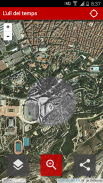
L’aplicació presenta la imatge del territori avui i en moure el cursor per la pantalla es visualitza una àrea circular on és mostra com era l’any 1945 (o 1956, a escollir).
Si activeu el posicionament veureu com era el lloc on sou i podreu veure les transformacions geogràfiques de l’indret. Això us donarà una experiència visual i una comprensió in situ.
Funcionalitats de l’aplicació:
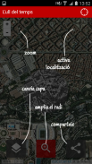
- A la part superior esquerra de la pantalla hi trobareu els botons de fer zoom.
- A la part superior dreta hi trobareu el botó per activar la vostra localització.
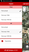
- Amb el botó inferior esquerra podreu canviar les capes a visualitzar i el seu mode (actual i històriques).
- Amb el botó inferior central podreu triar el radi de la finestra que mostra la cartografia històrica.
- Amb el botó inferior dret podreu compartir l’Ull del tems a les xarxes, en el punt on indiqueu.
Aquesta aplicació té alhora un vessant històric, urbanístic i lúdic.
Aquesta eina es basa en els vols fotogramètrics realitzats per la força aèria dels Estats Units d’Amèrica els anys 1945 i 1956 (copyright Army Map Service d’EE.UU, cedides pel Ministeri de Defensa -CECAF/CEGET- amb la col·laboració de l’Exèrcit de l’Aire), i amb la imatge actual realitzada per l’Institut Cartogràfic i Geològic de Catalunya (ara reutilitzable sota llicència CC-BY).
Trobareu una versió web d’aquesta aplicació a:
http://betaserver.icgc.cat/visor/catalunya_ull_del_temps.html
Si voleu adreçar-nos els vostres comentaris i suggerències feu-ho a betaportal@icgc.cat.
The eye is the mobile application of the Cartographic Institute of Catalonia Geological and you can see how it was in the past where you are and the rest of the Catalan territory.
The application presents the image of the country today and move the cursor around the screen displays a circular area which is shown as it was in 1945 (or 1956, to choose).
Enabling positioning watch was the place where you can see the changes and the geographic location. This will give you a visual experience and understanding in situ.
Features of the application:
- At the top left of the screen you will find buttons to zoom.
- At the top right you will find the button to activate your location.
- With the lower left button you can change the view layer and its mode (current and historical).
- With the central button below you can choose the radius of the window that shows the historical cartography.
- With the bottom right button you can share the Eye of fear to the network at the point where you specify.
This application has both a historical aspect, urban and playful.
This tool is based on photogrammetric flights made by the United States Air Force Years 1945 and 1956 (copyright US Army Map Service, provided by the Ministry of Defence -CECAF / CEGET- collaboration with the Air Force) and the current image made by the Geological and Cartographic Institute of Catalonia (now reusable under CC-bY).
You will find a web version of this app:
http://betaserver.icgc.cat/visor/catalunya_ull_del_temps.html
If you want to send us your comments and suggestions to do so betaportal@icgc.cat.


